How GIS Propelled Geography Into The 21st Century
14 November 2023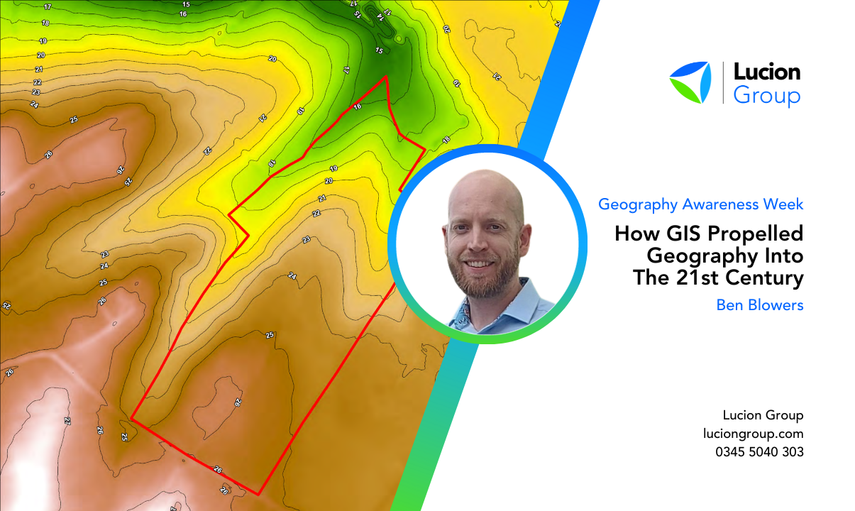
Geographic Information Systems (GIS) have played a pivotal role in propelling geography into the 21st century. This powerful technology has transformed the way we perceive, analyse, and understand our world. November 15th marks GIS Day, coinciding with Geography Awareness Week, an annual event that celebrates the importance of geography and its impact on our lives.
In recognition of this significant day and week, GIS & Digitalisation Lead Ben Blowers explores the ways in which GIS has ushered geography into the modern era.
The Evolution of Geography
Geography has been a foundational discipline for centuries, aiming to understand the world around us. It has evolved from early explorers' maps to a highly sophisticated field.
However, in the 21st century, the game-changer for geography has been Geographic Information Systems, or GIS. This technology has not only redefined how we perceive the world but also how we interact with it.
The Emergence of GIS
GIS emerged as a revolutionary tool for geographers in the latter part of the 20th century. It brought together various spatial data, from maps and satellite imagery to land use information, into a digital format.
Key figures in the development of GIS include Roger Tomlinson, who is often called the "father of GIS," and the Environmental Systems Research Institute (ESRI), a company that played a significant role in GIS software development.
Today, GIS is an integral part of our daily lives. It powers applications like GPS navigation in our cars and smartphones, making it easier to find our way. GIS is also fundamental to weather forecasting, helping us track storms and plan for changing weather conditions. In essence, GIS technology ensures that we're more connected, informed, and able to make decisions based on spatial information.
- GIS and Environmental Impact Assessments
-
Beyond facilitating everyday convenience, GIS has been a game-changer for environmental research and conservation. It enables scientists and environmentalists to monitor ecosystems, track climate change, and identify areas that require preservation. By mapping and analysing environmental data, GIS assists in making informed decisions about land use, wildlife conservation, and sustainable resource management.
- GIS and Urban Planning
-
Urban planners and city officials benefit significantly from GIS. It aids in optimising traffic flow, designing efficient public transportation systems, and planning for disaster management within cities. The technology empowers decision-makers to create more sustainable and resilient urban environments.
- GIS and Healthcare and Epidemiology
-
GIS plays a vital role in healthcare and epidemiology. It helps in disease mapping, tracking the spread of diseases, and optimising the allocation of healthcare resources. During a pandemic, for instance, GIS can identify outbreak hotspots, inform the public, and guide the allocation of healthcare facilities and resources.
- GIS and Social and Economic Impact
-
In the business world, GIS has become invaluable. It aids in business location analysis, market research, and disaster response planning. Companies use GIS to optimise their supply chains, analyse customer data, and make informed decisions about where to open new stores or offices. In disaster response, GIS technology helps coordinate and manage resources more effectively.
Field Data Collection with Mobile GIS Apps
In the modern era, GIS has expanded its reach by taking geography out into the field, thanks to mobile devices and specialised applications. Mobile GIS apps have transformed the way data is collected, making it more efficient, accurate, and accessible. Whether in the heart of a city or the depths of a remote wilderness, researchers, environmentalists, and urban planners can now gather real-time spatial data with ease.
Mobile GIS apps allow users to access geographic data, maps, and analysis tools on their smartphones or tablets. This capability is particularly valuable for on-site data collection, as it enables professionals to:
- Real-Time Data Collection
-
Mobile GIS apps enable the instant capture of location-based data. Researchers can record environmental measurements, urban features, or wildlife sightings and see the results in real-time.
- Integration with GPS
-
These apps integrate seamlessly with GPS technology, providing precise location information. This is crucial for mapping and geospatial analysis.
- Offline Data Storage
-
Many apps offer offline data storage and synchronisation capabilities, ensuring that field data can be collected even in areas with limited or no internet connectivity.
- Customised Forms
-
Field workers can create and use customised data input forms, making it easy to collect specific information tailored to their research or project needs.
- Photo Documentation
-
Mobile GIS apps often allow for attaching photos to data points. This is invaluable for visual documentation and analysis.
- Streamlined Data Sharing
-
Data collected in the field can be easily shared with colleagues and integrated into larger GIS databases and projects.
Whether it's assessing natural ecosystems, inspecting infrastructure, or conducting archaeological surveys, mobile GIS apps have revolutionised field data collection, bringing a new level of precision and efficiency to the world of geography.
GIS has a wide range of applications across various industries and sectors, including urban planning, environmental management, natural resource exploration, disaster management, transportation planning, agriculture, real estate, and more. It enables users to make informed decisions by visualising and analysing spatial data in a meaningful way.
For our clients, we offer a range of GIS-facilitated services including:
- Site Selection
-
We use GIS to identify the best location for a new asset such as an office, factory, solar farm or housing estate for our clients. We consider isochrones (travel distances) of people and other assets e.g. other offices, farms, and suppliers. We additionally consider constraints such as flood zones, protected areas, steep slopes, and distances to suitable roads.
- 3D SEMP
-
We use GIS and LIDAR data to visualise the topographical characteristics of a site. Thematic maps (red/amber/green), contours (1-metre intervals), elevation profile views and 3D oblique views are all presented in a map pack to allow stakeholders to grasp the topographical characteristics of a site at the due diligence stage. Indicative volumetric visualisations of soil movements can also be undertaken using a cut-and-fill style approach showing where the ground needs to rise and fall and even rough measurements can be calculated.
- Physical Climate Risk Assessments
-
We can run your portfolio of sites through our GIS models and climate risk databases to screen sites against various climate risk indicators such as temperature, heatwaves, wildfire, rainfall and wind and rank them.
- RAPID RAG - Fast Flood Risk Analysis
-
Using our GIS models and flood risk datasets, we can screen a portfolio of sites rapidly to establish which ones are at risk from flooding and rank them accordingly.
Our GIS services provide our clients with the means to be able to make highly informed decisions about optimal development sites in areas of interest, identify areas for risk mitigation development and facilitate early decisions in acquisition and divestment processes.
Geography in the Digital Age
In the digital age, Geographic Information Systems (GIS) stand as the cornerstone of modern geography. GIS has not only revolutionised the way we perceive and interact with our world but has also given us the tools to address some of the most pressing challenges of our time.
As we celebrate Geography Awareness Week, we must recognise the profound impact of GIS on our understanding of the Earth. It has propelled geography into the digital age, making the world more accessible, understandable, and interconnected than ever before.
GIS has transformed the field of geography from static maps and charts to dynamic, real-time data that empower us to make informed decisions. Whether it's optimising urban transportation, conserving the environment, or battling pandemics, GIS plays a pivotal role.
Moreover, the field data collection revolution, enabled by mobile GIS apps, has brought geography out of the classroom and into the heart of our cities, the depths of our ecosystems, and the most remote corners of our planet. This real-time data collection not only improves accuracy but also fosters an appreciation for the dynamic nature of our world.
As we navigate the complexities of the 21st century, GIS will continue to be the guiding light, helping us address environmental challenges, optimise urban development, improve healthcare, and enhance our understanding of the world.
Geography Awareness Week reminds us of the importance of geographic literacy and the role of GIS in shaping a more informed, connected, and sustainable future for all.
About The Author
Ben Blowers
GIS Lead - Environmental Planning
Ben is an experienced GIS Lead with over 13 years of experience in planning, environment and GIS for both the private and public sectors.
Ben uses his GIS and environmental consultancy experience to help clients navigate the complexities of planning policy. Ben has experience working on projects all over the world and has built many advanced mobile and desktop applications for data capture and data presentation.
He has specifically contributed to projects involving Environmental Impact Assessment (EIA), Environmental and Social Impact Assessment (ESIA), Ecological Impact Assessment (EcIA), Habitats Regulations Assessment (HRA), Biodiversity Net Gain (BNG), Flood Risk Assessment (FRA), as well as all of the protected species requirements (surveying and reporting).
E: ben.blowers@deltasimons.com
M: +44 (0)737 6634 071
T: +44 (0)1522 882 555
Linkedin: Ben Blowers
IMPACT Magazine
Industry news delivered by Lucion Group and its subsidiary companies.
Issue 2 May 2023

No sign-up required
Lucion Group Brochure
Lucion Group is a purpose-driven company where we protect people from hazardous environments and protect the environment from the impacts of people.
Find out about our suite of services with our overview services brochure.
No sign-up required